Discoveries Amid Living Beauty: Hiking the Black Mountains
[originally published April/May 2000 Blue Ridge Country]
Last October I had the rare chance to hike my favorite mountains in perfect weather. Stephen Thacker and I stumbled upon three days when North Carolina’s Black Mountain Crest Trail was neither locked in clouds, as it is 80 percent of the summer, or blocked by road closures, like it is much of the winter. This time, warm sunlight illuminated valleys of peak leaf color and views stretched to infinity. The sky was so clear we gambled on the fickle mountain weather and left our bulky tents behind.
By far the most popular of the Black Mountains is 6,684-foot Mt. Mitchell, the highest in the East. In recent years, Mitchell is known more for its acid rain and insect-killed forests than for its high-altitude appeal. Predictably, Stephen and I left the summit parking lot on a narrow path surrounded by tall gray toothpicks that were once healthy Fraser firs. Less predictably, this was the worst spot on the route, and it didn’t last long. Soon we dropped into a living forest, where cold-tolerant evergreens and boreal animals still evoke the Canadian heritage of an ecosystem pushed south by glaciers 20,000 years ago.
Seeing more dead trees didn't spoil our trip. We leisurely covered twelve miles of forest and vista, sleeping under the stars and climbing six 6,000-foot summits. As we reached trail’s end below the secluded headwaters of Bowlens Creek, I knew, once again, how Thomas Nuttall felt after exploring Linville Gorge two centuries ago: "I could not think of a better life than climbing the mountains."
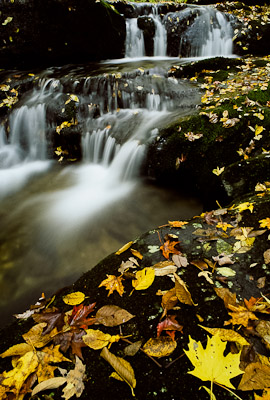
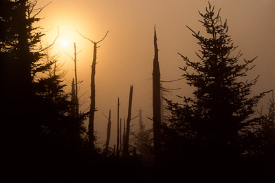 |
Sunrise on Mt. Craig (6,647'), Black Mountain crest. |
Modern camp stoves and well-worn trails take away little of the wildness that greeted the Blacks’ first explorers. No one knows who reached the summits first, although Cherokee Indians held mountain ceremonies and white settlers grazed animals in high meadows. Famed botanist Andre Michaux climbed high enough to observe northern species in the late 1700s, but it wasn’t until 1835 that a scientist, minister, and professor named Elisha Mitchell put the peaks on the map.
Mitchell made the week-long trip from Chapel Hill in June of that year, focusing his studies on "Geology; Botany; Height of the Mountains; Positions by Trigonometry; Woods, as of the Fir, Spruce, Magnolia, Birch; Fish, especially trout; Springs; Biography, &c. . .". It was a plan befitting a man known on the UNC campus as "the walking encyclopedia," with a schedule that would make many an ambitious baby-boomer sick with envy. Not only did he teach eight subjects, he wrote textbooks, preached at one of two churches most Sundays, and filled a variety of civic positions. He also happened to have five children, whom he taught himself.
Mitchell traveled the Blacks with local guides, using barometers and complex formulas to calculate elevations for several summits. The work exhausted the energetic 41-year old. "The roughness of the sides and top of the Black Mountain is likely to prevent [its] being often ascended from motives of curiosity and pleasure," he once predicted. His day trip to present-day Mt. Mitchell covered eighteen miles with a 3,800-foot elevation gain, where ". . . between one and two miles, it is thro’ thick laurels and along a bear trail."
For his efforts, Mitchell showed that his mountain was probably the highest in the United States, which at the time extended no farther west than Missouri. More importantly, he destroyed the old assumption that New Hampshire’s Mt. Washington was higher. The enthusiastic editor of the Raleigh Register took new pride in his state, proclaiming, "we now have it in our power . . . to LOOK DOWN upon such of our arrogant sisters of the [nation] as may insolently venture to taunt us with inferiority."
The professor’s work was not without controversy. In 1855, Congressman Thomas Clingman climbed the high peak, then claimed that Mitchell had never done so. Two men who were once close friends grew farther apart as each defended his claims in newspaper articles and personal pamphlets. Just when Clingman had the upper hand, Mitchell died suddenly in the Black Mountains, instantly becoming a martyr to his cause.
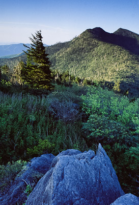 |
Looking south from Winterstar Mountain (6212') toward Potato Hill (6475') and Cattail Peak (6583'). |
My personal obsession with the Blacks began with summer work at Mt. Mitchell State Park. Living in a barracks an hour from civilization, I had plenty of time to discover a vast expanse of rugged lands just beyond the busy park facilities. In addition to rare alpine ecology, morning and evening hikes revealed fantastic sky colors, storm clearings, moonrises, and occasional alpenglow. Nighttime drives caught bear, deer, and bobcat in the headlights.
Yet, I realized how little of this is apparent to the many visitors who drive to the summit parking lot, walk 300 yards to an observation tower, and leave, all at midday when the Black Mountains are least impressive. In either harsh, hazy sun or spooky low clouds, the infamous dead trees stand out like needles in an oversized pincushion. Rangers hear "What’s killing the trees?" more than any other question.
The park’s 3/4-mile Balsam Nature Trail tackles the issue on the first page of its guidebook. Hikers need only feel brisk winds and cool air in July to appreciate the winter weather that has always killed some trees. Gusts over 100 miles per hour whip into spruce and fir heavy with rime ice in temperatures as low as -32° F.
The remaining stressors are man-made. Beginning in 1912, Mitchell’s virgin timber fell to unregulated logging practices that had about the same environmental impacts as an active volcano. Intense fires burned deep into soils that eroded as forest canopies vanished. Less than three years later, adventurer D. R. Beeson explored the range and remarked, "The whole mountain from here to the top on the east side is bare and burned over and not a pleasant sight at all."
Governor Locke Craig wasn’t impressed either, especially after being invited to a grand opening of the mountains’ new logging railroad: "When I looked all around, where I had been bear hunting as a boy, and saw this vast desolation all below, I told them they had gotten the wrong man to come up and celebrate the opening of their railroad. I felt like a man that stood amidst the ruins of his home after the conflagration had destroyed it." Craig described Mt. Mitchell as a "sacred place" given by God, and went on to establish the first 525 acres of North Carolina’s first state park in 1916.
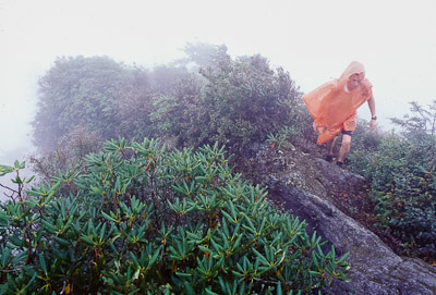 |
Hiking in clouds in the northern Black Mountains. |
Though the scattered meadows where Stephen and I camped are legacies of "scorched earth" logging, the forests largely recovered. Today's standing dead timber is the result of quieter but far more complex processes that increase the pressure of natural stresses.
Visitors have to look hard to find the white fuzzy patches on bark that give away balsam woolly adelgids, microscopic insects that attack Fraser firs but ignore red spruce. Often considered a natural threat, adelgids were actually imported to the U.S. from Europe on transplant trees, making them a human input. Since 1955, they have fed heartily in the Blacks, usually attacking older trees whose cracked bark permits easy entry. The new saplings that sprout beneath dead timber will probably succumb as soon as they reach maturity.
Meanwhile, the soupy low clouds that obscure visitors' views and give park workers claustrophobia pose serious threats for plants. High elevations make acid "rain" irrelevant, as trees absorb toxic compounds from clouds themselves. Cloud-borne nitric acid, sulfuric acid, and other pollutants arrive from as far away as the Ohio Valley. When rain does fall, heavy metals accumulate and soil acidifies.
Pollution from power stations and automobiles also react with organic compounds to produce low-level ozone, which hinders plants’ metabolic processes. Though present at other elevations, ozone persists longer and causes more stress at high elevations, particularly at night. Coupled with acid deposition, we get burned needles, withered roots, and weakened trees.
So, which factor does the most damage? This is a bit controversial and, perhaps, ultimately irrelevant. Logging is spilt milk, harsh weather is beyond control, and the balsam woolly adelgid has eluded predators and safe insecticides. Air pollution is all the public can change, but proving its part in forest decline has been difficult, politically speaking. Suffice it to say that the same pollution has been proven to harm human health and limit visibility by 80% in the southern Appalachians, which gives a hike on some trails the same basic effect as climbing a Houston high-rise.
Still, the mountains of Michaux and Mitchell have hardly disappeared. Consider that the moody cover of S. Kent Schwartzkopf’s A History of Mount Mitchell and the Black Mountains portrays a whole foreground of skeletal trees – not surprising, except it comes from an engraving made way back in 1874. On a purely aesthetic level, perhaps the greatest difference between the old days and now is not the condition of the forests but the way we typically travel them. By 1929, veteran hiker C. Hodge Mathes was already writing of Mt. Mitchell’s new roads and tower with a sense of loss:
"This mountaineering de luxe does not give much of a thrill to those of us who used to camp under the big [rock] just below the top. . . . Dearer to us were those never-to-be-forgotten nights under the stars, where the cool wind in the balsams and the occasional scream of a wild cat or a mountain owl gave us a weird sense of solitariness, knowing we were the only human beings in the vast loneliness of the Black Mountains."
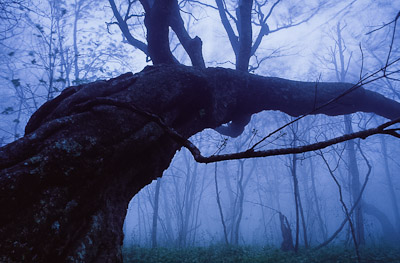 |
Twisted maple near Flat Spring Gap, western Black Mountains. |
The park for which I worked has grown considerably from its founders’ vision. With 1,800 acres at last count, opportunities for both "mountaineering de luxe" and primitive wildness flourish in keeping with a 1937 master plan that limited development in some areas while allowing creature comforts in others. Sweaty hikers can finish remote, multi-day treks at the park restaurant, where fine steaks, mountain trout, and tender chicken are served under a high wooden ceiling with picture windows overlooking Mt. Mitchell’s southwestern slopes.
The park’s limited official acreage belies the sizable expanse of wild lands contained in the Blacks but managed by other agencies. Drivers are understandably confused after turning from the National Park Service’s Blue Ridge Parkway onto N.C. Highway 128, which leads to Mt. Mitchell State Park through land managed by the U.S. Forest Service. A huge private hunting preserve separates public land between the two major ridgelines.
All told, the range offers more than 20,000 acres to the public, the equivalent of a quarter of the total Parkway. Sixty miles of hiking and horse trails vary in degree from the wild and woolly Black Mountain Crest Trail to the unusual Trail of Four Senses on the restaurant lawn, where blind visitors follow a roped course while cassette tapes interpret points of interest.
Those who want the full experience must search their favorite guidebooks and relevant topo maps. The park brochure shows only state-owned land, leaving out many of my favorite haunts, such as the northern eight miles of the Black Mountain Crest Trail and, on the southern end of the range, five exquisite miles of the Mountains-to-Sea Trail (see Elizabeth Hunter’s article on page 48 of the Sept/Oct 1997 BRC). It also ignores the entire western arm of peaks, where a six-mile path alternates between needled stands of old-growth spruce and grassy groves of beech and birch. Here, Elisha Mitchell climbed an outcropping, scanned the crest, and first noted that Mt. Mitchell was probably the highest point in the area.
 |
Bowlens Creek, northern Black Mountains. |
Distinct plant communities have always made the Blacks more than a sky-high playground. Andre Michaux and Elisha Mitchell began a scientific tradition that seized the chance to study Southern Appalachian hardwoods and Canadian conifers within 3 miles of each other. This diversity was one good reason for forming one of the U.S. Forest Service’s first Research Natural Areas in the Middle Creek drainage below three of the Blacks’ highest peaks.
Set aside for "the purposes of maintaining biological diversity, conducting non-manipulative research and monitoring, and fostering education," more than 250 RNAs now allow long-term studies in varied ecosystems across the country. The Black Mountains’ RNA covers 1,263 acres, with more than 3,500 feet in elevation between the flanks of the South Toe River and the summit of Balsam Cone. The writers of a 1932 reconnaissance report extolled the tract’s virgin timber, commenting on the "steep slopes and inaccessibility" that kept human development to a minimum. I felt like I’d traveled in time as I looked at an old map that showed isolated grazing fields, mining prospects, and acre after acre of chestnut forests, just recently infected with blight.
Whenever I mentioned the Middle Creek area, Don MacLeod’s name came up. The botanist from Mars Hill College established permanent field plots in 1981, then surveyed the relationships between plant communities and environmental factors. His results helped model future work in both the Blacks and the Great Craggy Mountains, while university students used his plots for later studies.
When I finally called MacLeod at home below the peaks, I sensed the same spirit of adventure that drives others into the mountains for sheer recreation. He, too, had discovered the range’s unique appeal, both on and off established trails. When he mentioned the time he felt like the "first white person" to set foot in a certain cove, I could relate. The joy of traveling such wild terrain often depends less on its beauty than on the accompanying belief that no one else is around to appreciate it.
Perhaps the whole long line of Black Mountain scientists and explorers was similarly inspired. After Elisha Mitchell, geographer Arnold Guyot painstakingly remeasured the major summits, producing figures that fall within forty feet of the N.C. Geodetic Survey’s 1993 satellite data. Paleontologist Edward Cope appeared in the 1860s, hypothesizing that many of the animals he observed were identical to those 1,000 miles to the north. William Brewster and J. S. Cairns proved him right in the 1880s and ‘90s.
The U.S. Weather Bureau made Mt. Mitchell an official recording site in the 1920s and ‘30s, giving observers the dubious thrill of gathering high-altitude data on long, windy nights near the summit. (Mt. Mitchell has yet to beat its old rival, Mt. Washington, which boasts the "world’s worst weather" and the planet’s all-time wind record of 231 mph.)
In the 1980s, Dr. Robert Bruck investigated acid deposition in various plots on the mountain. Though his work supplied convincing evidence that pollution plays a major part in tree decline, funding was cut within ten years. Bruck still checks his old plots every year, and a station on Clingman’s Peak monitors cloud chemistry, but, as of this writing, that is the extent of acid deposition research in the Black Mountains.
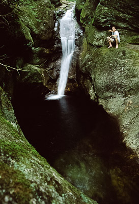 |
Mitchell Falls. |
Elisha Mitchell’s death in the Blacks in 1857 caused quite a stir, beginning with the immediate problem of finding his body. The terrain was so formidable that, at one point, the hardy search party suggested giving up until vultures circled over his location. Only after a local tracker named Big Tom Wilson took over did they pick up Mitchell’s trail. Scrambling alone in the tangled underbrush, the professor had slipped from a 40-foot waterfall, drowning in the pool below.
Today, no trail connects the crest to the falls, which is on private land. On a clear July morning, Stephen Thacker and I plunged into dense forest above Mitchell Creek, hoping to find the historic spot. After endless contortions through rhododendron thickets, slick boulders, and downed timber, we reached a loud cascade above an unmistakable dark pool. I set up my camera for long exposures while Stephen climbed a rock beside the water. The resulting images bear a striking resemblance to a picture in the park museum, with Big Tom sitting on the same rock around the turn of the century.
Experiences like this remind me that the Black Mountains are very much alive, despite the tragic decline of two prominent tree species.
©Stephen Schoof