Discovering DuPont: A Look at
North Carolina's Newest State Forest
[originally published March/April 2004 Blue Ridge Country]
I usually turn to my weathered third edition of Allen deHart’s North Carolina Hiking Trails for the last word on local destinations. When I first looked up DuPont State Forest, I needed a moment to grasp why it wasn’t in the index. The forest, like the book, was only four years old.
North Carolina quietly purchased 7,600 acres from the DuPont corporation in 1996, establishing a horseshoe of public land on a modest plateau in the Little River valley southwest of Hendersonville. A smaller purchase closed the circle in spring 2000, but the middle portion – 2,200 acres with three spectacular waterfalls – didn’t come until later that year. The state’s six-month negotiations with a developer finally ended in a controversial taking by eminent domain.
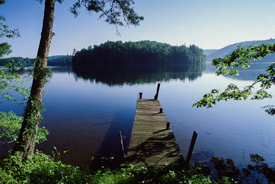 |
Lake Julia. |
Parts of the new tract were still officially closed when I met Woody Keen, then a mountain bike sales rep and a former leader in Friends of the Falls, at the main gate in March 2001. A forecast for morning rain had turned into clear skies and an early warm spell -- a fine day for a grand tour of the new property, which the tall, bearded, athletic Keen had arranged in his VW van, “so we can cover more ground.”
Friends of the Falls had recently disbanded, having successfully campaigned for the state to acquire the now-famous middle tract. The road to controversy began innocently enough when DuPont's medical division was bought out and the company sold extra land to North Carolina for a cut-rate price. Until then, the property had been private for decades. DuPont needed pure water for its processes, and the Little River fit the bill. Owning thousands of acres not only preserved the watershed, but gave employees free roam of the lush hardwood forests, 3,000-foot peaks, and incredible waterfalls surrounding their workplace.
Locals will vouch for the company’s policy toward outsiders. “Say you had wanted to come take pictures -- all you had to do was pick up the phone and ask,” Keen told me. Thus, those in the know came to love the property, while it stayed virtually unknown to everyone else.
The state’s 1996 acquisition suddenly opened dozens of trails to enthusiastic hikers, bikers, and equestrians. Casual riders in particular could enjoy easier routes than the hard-core single-tracks of nearby Pisgah National Forest. Included were long stretches of riparian forest punctuated by Hooker Falls and Wintergreen Falls, plus pock-marked domes with 360-degree views on Cedar Rock and Stone Mountains. Still missing were the coveted Triple, High, and Bridal Veil Falls, plus two artificial lakes left over from an old summer camp. All this was put up for bid by DuPont’s successor, the Sterling Group, in 1999.
Local supporters urged Sterling to simply sell to the state -- sentiments echoed in personal phone calls by both former North Carolina Governor Jim Hunt and (thanks to the company’s Houston connections) former Texas Governor George W. Bush. But in the end – and partly because of vague deed restrictions that seemed to limit the tract’s value – North Carolina came in third among seven bidders, and the land went to a developer from South Carolina.
“We were disappointed,” Keen said, but he added that conservationists were not ready to seek a condemnation until the owner announced construction of up to 100 (later as many as 350) large, luxury “vacation cabins.”
Faced with a permanent hole in its property, the state was more concerned with ensuring public access to the feature falls and several trails that dead-ended at the property line than with environmental issues. Though both sides met repeatedly for a compromise, talks broke down and North Carolina took the property for a $12.5 million compensation (upped to $24 million after legal challenges).
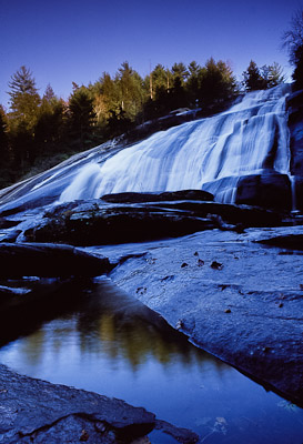 |
High Falls. |
Keen and I soon stopped at an old picnic shelter above Triple Falls, where three good-sized cascades pound over granite shelves on a wide bend in the river. As we studied before-and-after pictures of a trail crew digging erosion control, a senior hiker with a young woman, baby, and dog promptly asked how he could get involved.
“That's not uncommon,” Keen said later. “People feel a strong sense of ownership about this forest.” The highly publicized acquisition energized volunteers as much as it riled the smaller number of property rights proponents who saw the action only as a government land grab. Keen emphasized that trail work, sign posting, and other maintenance was being done by weekend groups of two dozen or more. One equestrian group, the Pisgah Trailblazers, puts in 1,000 hours each year.
No help will be declined anytime soon; at the time we talked, the new forest had no permanent staff and relied instead on system employees rotated from around the state. We drove the property on just a few of the 98 trails, totaling 89 miles, listed on the current forest map. Along the way were lakes, stables, a landing strip, and a hodgepodge of half-finished buildings. The management is as considerable as the recreational possibilities. Keen, for example, saw particular potential on Lake Julia, where we poked around a brand new boathouse and old, partly-renovated camp buildings nestled below a wooded knob. Though floors were dusty and plastic covered some of the windows, the place could someday support canoe and bike rentals, a swimming area, or restaurant service.
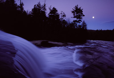 |
Bridal Veil Falls. |
This wealth of recreational potential may seem overkill for the N. C. Forest Service, which is not, in the words of Regional Forester John Pearson, “in the business of recreation.”
As the new waterfall tract opened, Pearson and I talked at a local office stocked with information on tree planting, prescribed burns, wildlife plots, and stewardship programs. The agency’s mission is not unlike that of the U.S. Forest Service, which, of course, eternally butts heads with environmentalists over timber production and preservation.
Yet I heard more than one environmentalist praise Pearson’s management skills, while he clearly appreciated the nature-loving bikers, hikers, and retirees breaking sweat on DuPont’s new facilities. Topping his list of six objectives was protection of natural resources, specifically water quality and soil integrity.
“All of our management strategies revolve around that,” he told me. “It’s sort of an overriding objective for everything we’ve got going out there.”
Some of what’s going includes thinning, harvest cutting, and prescribed burning, mostly on the “old” section acquired in 1996. All will be on a relatively small scale and mostly for educational purposes.
“Our primary focus is on service to non-industrial private landowners, giving forestry advice. If they want to do some cutting, we can advise on that. If they want to do reforestation, we’ll work with them on that. We’re trying to set up demonstration areas so that if a landowner is unclear about what something looks like, we can bring them out and show them.”
From high ground, alert visitors can already spot even-aged white pine plantings, started decades ago by DuPont. But the wildest, most scenic areas will probably stay that way. On a detailed topo map, Pearson indicated places designated Natural Heritage Areas for having rare plants or unusual geology. Those labeled “primary” will be left alone, surrounded by “buffers” that allow some forest management, before merging into “excluded” areas that are open to demonstration cutting.
Also unlike a state park, the agency will maintain wildlife habitat as part of its cooperation with the Wildlife Resources Commission game lands program. Through annual lotteries, the Commission allows limited hunting on certain days, away from high-visitation safety zones. Some 20 helispots cleared for fire-fighting serve double-duty as food plots for deer, turkey, and bear.
And finally there’s recreation. Pearson again emphasized that recreation isn't the forest service’s primary mission – “that’s state parks.” But he also emphasized “accommodation” as the keyword for his agency’s approach to the tide of visitors rolling its way.
“That’s probably the bottom line on this whole thing – we’re looking at a multiple-use forest, with not only recreation but also some timber management,” Pearson said. “We’re going to accommodate it as much as we can, but we’re not going to be a state park.”
Given the area’s potential, I had to ask the obvious: Why didn't North Carolina just go for state park status in the first place?
“Initially, it was discussed,” Pearson said, referring to an old document. But the fact that the main waterfalls were left out of the original tract proved problematic. He quoted: “‘The division of state parks is not interested in adding [DuPont’s property] to their holdings because most of the unique areas worth preserving…were conveyed to Sterling Chemical.’”
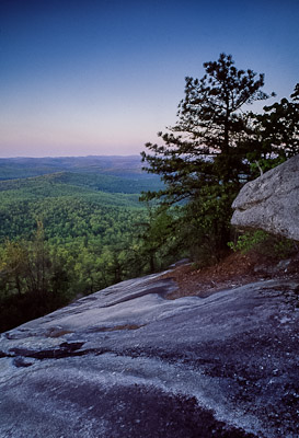 |
Spring dawn on Stone Mountain. |
Three years later, the Forest Service is holding fast to this original vision, except for recreation. A huge increase in visitors has the agency (and personnel from NC State) studying four alternatives for future management, ranging from the current low-impact approach (foot, bike, and horse travel, with no overnight camping) to an intensive plan for full-service campgrounds and vehicular access to major scenic attractions. It has also hosted numerous events, including a YMCA trail marathon, Army Reserve training, and a trails school. Volunteers continue to log hundreds of hours helping the permanent staff of seven maintain or improve trail networks.
Any major changes are a long way off, but are already open to public comment and suggestion. Many long-time users would love to allow carefully monitored, walk-in camping, but cringe at the thought of dozens of cars descending upon favorite destinations. Now is the time for visitors to explore the forest for themselves, and then decide how it should best be managed – and preserved – for decades to come.
©Stephen Schoof