Something Different in the Sauratowns
[originally published as "Discovering the Sauratowns" in September/October 2000 Blue Ridge Country]
I'm thankful that I live just an hour from the Great Smokies, forty-five minutes from Mt. Mitchell, and seven short miles from the Blue Ridge Parkway. Despite my best efforts to hike every regional trail and climb most of the accessible mountains, I find my to-do list getting longer every year. Many out-of-towners might be surprised that someone with such a big backyard would bother driving three hours to explore smaller mountains poking from North Carolina's flat and rather civilized Piedmont.
Hanging Rock and Pilot Mountain State Parks contain over 10,000 acres in the ancient Sauratown Mountains, but lack the lofty grandeur and wild character of my local peaks. Undeniable, however, is the appeal of their high quartzite cliffs, moderate woodland trails, and isolation from other mountain ranges. Part of their popularity stems from their proximity to major cities, especially Winston-Salem 25 miles to the south. For me, they provide a pleasant alternative to tramping the main Blue Ridge escarpment.
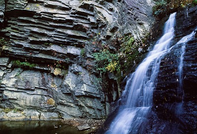 |
Lower Cascade Falls, Hanging Rock State Park. |
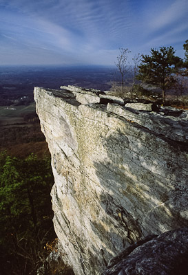
Hanging Rock is the larger and wilder park, with over 18 miles of trails covering 6,457 acres. Those who stay in the car won’t see much geology, but it’s just 2 ½ relatively easy miles to the park’s namesake summit and back. Here, ancient white quartzite drops 200 vertical feet into the surrounding forest and, even at a modest 2,150 feet above sea level, provides sweeping views over the Piedmont. To the east are dual ridges containing Moore’s Wall and Cook’s Wall, where higher cliffs offer pitches up to 5.14. Out of sight in the woods below, but accessible by other trails, are four unique waterfalls on Indian and Cascade Creeks. Both a man-made lake and the nearby Dan River offer swimming, boating, and fishing.
 |
Hanging Rock summit. |
Thirty minutes away on Pilot Mountain, a paved road that is steep enough to warrant its own rating system leads within a stone’s throw of 2,420’ Big Pinnacle, the main summit named Jomeokee, or “Great Guide,” by early Saura Indians. Its looming presence is obvious even to modern travelers on four-lane U.S. 52, which runs below the Pilot’s east face.
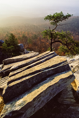
The Pinnacle itself is a quartzite monadnock, a dome of hard rock capping the more eroded schists and gneisses of the surrounding hill country. Though off-limits to climbers, an easy trail cuts a mile loop below the 200-foot cliffs. Other trails lead to climbable cliffs that offer equally impressive views of the farms and communities 1,400 feet below.
All of this is in the larger Mountain Section of the park. The rest of its 3,703 acres is 5 ½ miles away, where there's canoeing, rafting, fishing, and hiking along the Yadkin River. A 300-foot wide corridor connects the two sections for foot and horse traffic, providing an enjoyable day trip for those who'd like to see both areas without getting back on the road. (Next to this River Section is the Horne Creek Farm State Historic Site, whose house, outbuildings, and spacious grounds give visitors a taste of agricultural life in the early 1900s.)
 |
Cliff along Ledge Spring Trail, Pilot Mountain. |
So, which park is better? Hanging Rock certainly has a greater variety of cliffs and waterfalls, but the specter of Pilot Mountain jutting out of nowhere is hard to beat. Pilot’s overlooks are easier to access, but Hanging Rock’s have more wild appeal. In the end, both are worth visiting, especially for those of us who sometimes think we’ve already seen it all in the southern Appalachians.
©Stephen Schoof